MinView

MinView is a web map application that provides free access to view, search and download a comprehensive range of geoscientific data for NSW.
It contains the most comprehensive geology map of NSW and a complete stratigraphic legend for all major rock units in the state. There are also a wide range of supporting data layers including current and historical exploration and mining titles, areas of exploration constraints and property information.
There are over 500 map layers available and a host of information to explore.
Technical support and feedback
For technical support or to provide feedback on MinView, contact minview.info@geoscience.nsw.gov.au.
For questions relating to titles, contact titles@regional.nsw.gov.au.
To submit an exploration licence application, please visit the Titles Management System.
Data available in MinView
- Geological mapping data including the NSW Seamless Geology data package
- Scanned and georeferenced geological maps at a range of scales including coalfields, coastal and metallogenic mapping
- Potential coal release areas and exclusion areas mentioned in the NSW future of coal statement
- Geological basins and provinces
- Locations of recorded mineral occurrences
- Locations of mineral specimens with photographs and microfossils stored at the WB Clarke Geoscience Centre
- New statewide geophysical image merges, including the best available company flown data at high resolution (total magnetic intensity and isostatic gravity)
- Drillhole locations and related sample information
- Locations of drillcore stored at the Londonderry and Broken Hill core libraries
- Surface sample locations and downhole geochemistry
- Geological observations and measurements, including stratigraphical and lithological descriptions, and structural and petrophysical measurements
- Geochronological data
- Mining title administrative layers
- Mineral claims (opal) and opal prospecting administration boundaries
Features and functionality
- A new way to search – quickly find exploration and mining titles using the combined title/address/LGA/property search
- Extended searching – using the same tool and then undertaking a spatial search finds data in other layers that intersects or is within the selected application or title
- NSW Seamless Geology – combining all 11 geologic time slices and a surface geology layer
- Download government and company geophysical surveys – airborne magnetics and radioelement data as well as direct links to seismic survey data (SEGY files and grids)
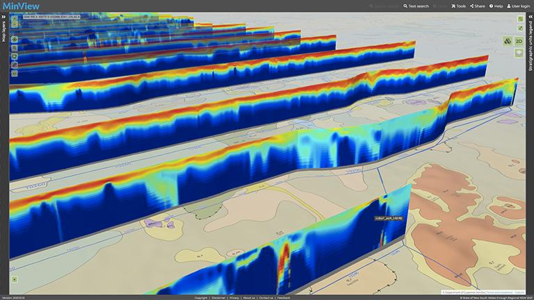
- View the AEM survey curtains in 3D
- A new way for users to add data – use KML/KMZ files and CSV WKT files previously exported from MinView using the export to CSV tool
- View groundwater bore information – with links to Water NSW real time water data and reports
- Use My views – create your own views with custom sets of layers you can load any time
- Draw on the map – add your own labels or graphics to the map
- Share your map – immediately share your view or print to PDF
- Download data – select the whole of NSW or clip to the current map view
- Register for email alerts – see when changes to exploration and mining titles happen
- View surface and basement elevation data in 3D – change globe vertical exaggeration and shadows on the fly.
If MinView does not appear with these features and functionality, try refreshing your browser (hold down CRTL and press the F5 key at the same time).
Register to receive alerts and save customised map views
Registered users can set an alert to be notified by email when a title changes or is due to expire. They can also save customised map views.
In MinView, choose the User login icon to create a new account or update your profile.
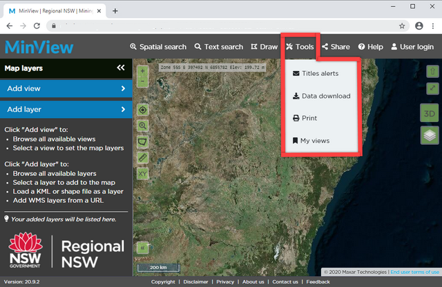
Choose the Tools menu to access Alerts and My views
If you have an account in the DIGS system, you can log in with your existing details. The one account will access the additional features of both applications.
Please note that your email address is collected by the Geological Survey of New South Wales (GSNSW) during registration for the purpose of activating these additional features and keeping users informed of planned outages or releases of new features. This information will not be distributed to any other parties. You can unsubscribe from these services at any time by emailing minview.info@geoscience.nsw.gov.au with 'Unsubscribe' in the subject field.
Use of data
The GSNSW's data available for download from MinView is licensed under Creative Commons Attribution 4.0 International (CC BY 4.0) See more information.
User guide
Information about titles
For further information
Contact us about MinView