Seamless geology project
NSW Seamless Geology update
An update to the NSW Seamless Geology Data Package (version 2.3) was released in May 2023 and includes the following features.
- Australian Capital Territory and Jervis Bay Territory borders were added to all relevant Seamless Geology layers.
- Updates to the Narooma Terrane rocks on the NSW South Coast.
- Ten inliers of basement rocks (Ordovician Tucklan Formation) were added between Dunedoo, Merrygoen and Neilrex.
- Updates to the geology of the Leadville–Narangarie area (east of Dunedoo).
- Updates to numerous polygons and attributes in the Ordovician Kiandra Volcanic Belt and Rockley–Gulgong Volcanic Belt units.
- Rosemeath Formation and the Hospital Porphyry were added to the dataset.
- Updates and additions to numerous Carboniferous and Devonian granitic rocks of the Burragorang 1:100,000 map sheet area.
- Detailed geological mapping of the Ben Bullen Igneous Complex was added to the dataset.
- Significant upgrade to the geology of the Talbingo–Yarrangobilly–Cabramurra area.
- Detailed geological mapping over the Mount Dromedary Igneous Complex was added to the dataset.
- Numerous issues with the sub-Adelaidean unconformity, Curnamona Province, were fixed.
- Changes to areas of Quaternary alluvial cover near Dubbo.
- A ‘Mafic’ Boolean attribute was added to the dataset.
- The Late Devonian rocks of the Rydal and Tarana Synclines (west of Lithgow) was significantly upgraded.
- Intrusive Carboniferous and Devonian rocks of the Katoomba and Wallerawang 1:100,000 map sheet areas were substantially updated.
- Attribute updates and minor error fixes to all layers.
The dataset is also available in a single layer version, in which the various time slices have been flattened into a single layer, effectively presenting the surface geology only.
The data packages are available in the GDA94 and GDA2020 datums.
Datasets available for viewing and download
- NSW Seamless Geology Data Package available in ArcMap (10.4 or later) and ArcGIS Pro (3.04 or later), MapInfo (11.5 or later) and QGIS (3.28.4 or later). A GDA2020 version of this package is also available.
- Single layer version of the NSW Seamless Geology dataset. A GDA2020 version of this package is also available.
- Viewable map on iPhone and Android phones and tablets
- Statewide seamless geology on MinView
- Reports on DIGS
Value-added and related products
Numerous products using the NSW Seamless Geology Geodatabase have been generated or are in preparation. These include:
- Fault attribution work for Zone 54 (report), the eastern Lachlan Orogen (report) , the western Lachlan Orogen (report in progress), and the Southern New England Orogen of NSW (report). All completed fault attribution data is included in the latest NSW Seamless Geology Data Package.
- Metamorphic maps of Zone 54, Zone 55 and Zone 56.
- NSW outcrop (bedrock exposure) and soils map (data available in the latest NSW Seamless Geology Data Package).
- Integration with 3D Mapping of NSW
- Integration with Mineral Potential Mapping of NSW
- Detailed stratigraphic unit tables for all units in the Seamless Geology Geodatabase (in progress).
What is the NSW Seamless Geology?
- An initial five-year project (2013–2018) to complete Version 1 of the statewide product.
- Joins the best-available geological mapping (on a variety of scales) across NSW.
- Connects line mismatches (e.g. geological boundaries, faults etc.) across existing geological map sheet boundaries.
- Harmonises stratigraphic units across NSW.
- Forms an integral part of ongoing work such as 3D, mineral potential and metamorphic mapping across NSW.
- Will be a continuously updated dataset, with new versions released at regular intervals.
- For a detailed explanation of the methods used in the NSW Seamless Geology Project, see the Quarterly Note 145 of the Geological Survey of NSW (GSNSW).
Features of the NSW Seamless Geology dataset
- Data is presented as a series of lithotectonic layers/provinces that form geological time-slices (see figure below), ranging from the Palaeoproterozoic structural and metamorphic evolution of the Broken Hill Block, to the Quaternary depositional systems of the east coast.
- It includes extensions of outcropping geology undercover (i.e. solid pre-Permian basement beneath younger sedimentary basins and unconsolidated sediments).
- A standard database structure and schema contain comprehensive attribute tables for each stratigraphic unit, enabling detailed querying and extraction of datasets such as geology, structure, metamorphism and geochronology.
- Free download is available in a variety of formats including GIS, mobile phone maps and online portals.
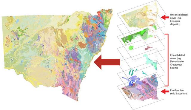
The NSW Seamless Geology dataset composed of lithotectonic layers/provinces
We would like your feedback
The NSW Seamless Geology dataset is compiled from the best available mapping - mostly from the GSNSW, with some thesis mapping. The data will be continuously improved by fixing identified issues, future GSNSW mapping programs and incorporation of better-quality company or thesis mapping, with periodic updates to improve the NSW Seamless Geology dataset.
Our aim is to make this dataset the authoritative source of geology for NSW.
So, if you find a problem or if you know of better mapping - please let us know.
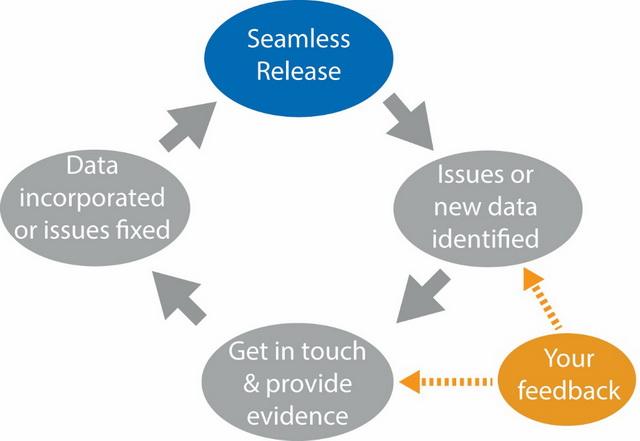
NSW Seamless Geology project workflow