Seamless geology project
NSW Seamless Geology update
An update to the NSW Seamless Geology Data Package (version 2.4) was released in May 2024 and includes the following features.
- Updated geology of the Cadia Valley and Lake Cowal districts using the latest published data.
- Updates to the Gidginbung Volcanics, Gunningbland Formation, and Billabong Creek Formation (Lachlan Orogen, central NSW).
- Updates to the mapping and nomenclature of the peralkaline Mesozoic volcanic rocks and intrusions around Toongi (22 km south of Dubbo), now termed the Benolong Volcanic Suite.
- A significant boundary upgrade in the Lightning Ridge region between the Cretaceous Rolling Downs Group outcrop / subcrop areas and the Quaternary black soil alluvial plains (Marra Creek Formation).
- A major review and update of the western margin of the Sydney Basin.
- Updated Llandovery-Wenlock geology of the Angullong Syncline, Bridge Creek, and Quarry Creek areas west of Orange.
- The addition of a large amount of new structural data from the Merimbula Group.
- Attribute updates and minor error fixes to all layers.
The dataset is also available in a single layer version, in which the various time slices have been flattened into a single layer, effectively presenting the surface geology only.
The data packages are available in the GDA94 and GDA2020 datums.
Datasets available for viewing and download
- NSW Seamless Geology Data Package available in ArcMap (10.4 or later) and ArcGIS Pro (3.2.1 or later), MapInfo (11.5 or later) and QGIS (3.34.4 or later). A GDA2020 version of this package is also available.
- Single layer version of the NSW Seamless Geology dataset. A GDA2020 version of this package is also available.
- Viewable map on iPhone and Android phones and tablets
- Statewide seamless geology on MinView
- A report on all updates to the Seamless Geology since its first release in October 2018 is available in DIGS.
Value-added and related products
Numerous products using the NSW Seamless Geology Geodatabase have been generated or are in preparation. These include:
- Fault attribution work for Zone 54 (report), the eastern Lachlan Orogen (report) , the western Lachlan Orogen (report in progress), and the Southern New England Orogen of NSW (report). All completed fault attribution data is included in the latest NSW Seamless Geology Data Package.
- Metamorphic maps of Zone 54, Zone 55 and Zone 56.
- NSW outcrop (bedrock exposure) and soils map (data available in the latest NSW Seamless Geology Data Package).
- Integration with 3D Mapping of NSW
- Integration with Mineral Potential Mapping of NSW
- Detailed stratigraphic unit tables for all units in the Seamless Geology Geodatabase (available as part of the latest NSW Seamless Geology Data Package).
What is the NSW Seamless Geology?
- An initial five-year project (2013–2018) to complete Version 1 of the statewide product.
- Joins the best-available geological mapping (on a variety of scales) across NSW.
- Connects line mismatches (e.g. geological boundaries, faults etc.) across existing geological map sheet boundaries.
- Harmonises stratigraphic units across NSW.
- Forms an integral part of ongoing work such as 3D, mineral potential and metamorphic mapping across NSW.
- A continuously updated dataset, with new versions released annually.
- For a detailed explanation of the methods used in the NSW Seamless Geology Project, see the Quarterly Note 145 of the Geological Survey of NSW (GSNSW).
Features of the NSW Seamless Geology dataset
- Data is presented as a series of lithotectonic layers/provinces that form geological time-slices (see figure below), ranging from the Palaeoproterozoic structural and metamorphic evolution of the Broken Hill Block, to the Quaternary depositional systems of the east coast.
- It includes extensions of outcropping geology undercover (i.e. solid pre-Permian basement beneath younger sedimentary basins and unconsolidated sediments).
- A standard database structure and schema contain comprehensive attribute tables for each stratigraphic unit, enabling detailed querying and extraction of datasets such as geology, structure, metamorphism and geochronology.
- Free download is available in a variety of formats including GIS, mobile phone maps and online portals.
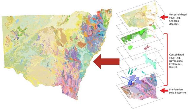
The NSW Seamless Geology dataset composed of lithotectonic layers/provinces
We would like your feedback
The NSW Seamless Geology dataset is compiled from the best available mapping - mostly from the GSNSW, with some thesis mapping. The data is continuously improved by fixing identified issues, future GSNSW mapping programs and incorporation of better-quality company or thesis mapping, with periodic updates to improve the NSW Seamless Geology dataset.
Our aim is to make this dataset the authoritative source of geology for NSW.
So, if you find a problem or if you know of better mapping - please let us know.
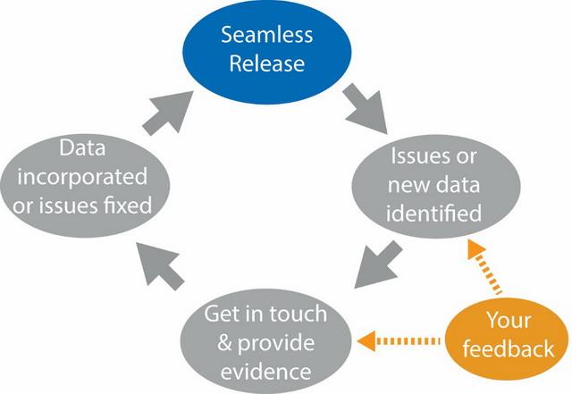
NSW Seamless Geology project workflow