Geophysical images and data
New! Geophysical images of NSW for Android or Apple phones or tablets are now available.
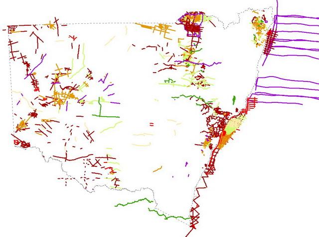
Airborne magnetic, radioelement and elevation surveys
Airborne magnetic surveys measure variations in Earth's magnetic field due to magnetic minerals in the ground, principally magnetite and/or pyrrhotite. Radioelement surveys measure the surface distribution of the naturally occurring radioelements, potassium, thorium and uranium. Topographic elevation is measured by the aircraft radar-altimeter.
The NSW Government has been acquiring airborne magnetic, radioelement and Digital Elevation Model (DEM) data through various funding initiatives since 1991. These surveys were undertaken in partnership with Geoscience Australia under National Collaboration Framework agreements. Smaller surveys have also been flown over some coal basins as part of the Coal Resource Identification Program.
Previously, the entire state was covered at 1500 m line spacing as part of the Bureau of Mineral Resources airborne geophysical surveying of Australia between 1951 and 1980. In some parts of the state this remains the only government magnetic and radiometric data, however,about 88% of NSW has since been surveyed at 400 m line spacing or closer.
You can download all NSW Government airborne survey located, grid and image data for free through MinView. Some surveys are also available through the Geoscience Australia Geophysical Archive Data Delivery System (GADDS).
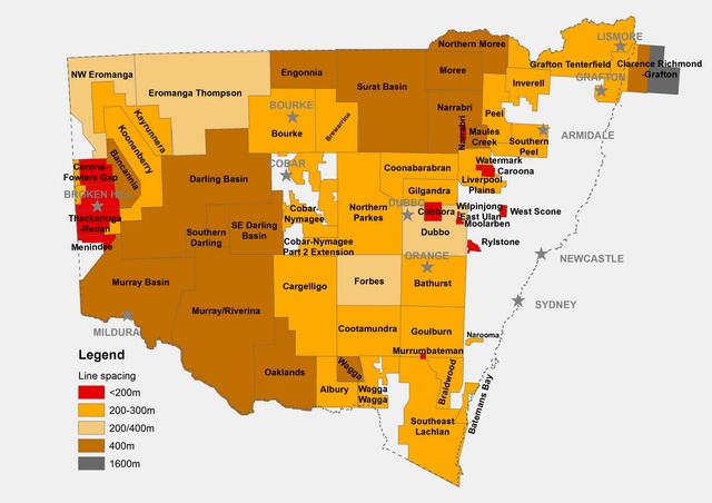
Airborne magnetic, radioelement and DEM survey areas
Ground gravity surveys
Gravity surveys measure the effect of variations in rock density on Earth's gravitational field.
The NSW Government is acquiring ground gravity readings across NSW, with about 73% of the state covered with 4x4 km or closer readings.Ground gravity data from across NSW can be downloaded for free through MinView or the Geoscience Australia Geophysical Archive Data Delivery System (GADDS).
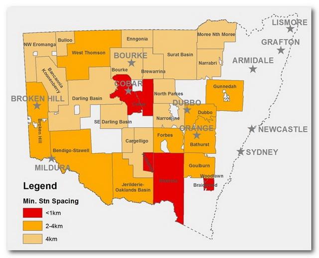
Location of ground gravity surveys
Airborne gravity surveys
Government-funded airborne gravity surveys have been completed over the Broken Hill area. Data from these surveys can be downloaded for free through MinView.
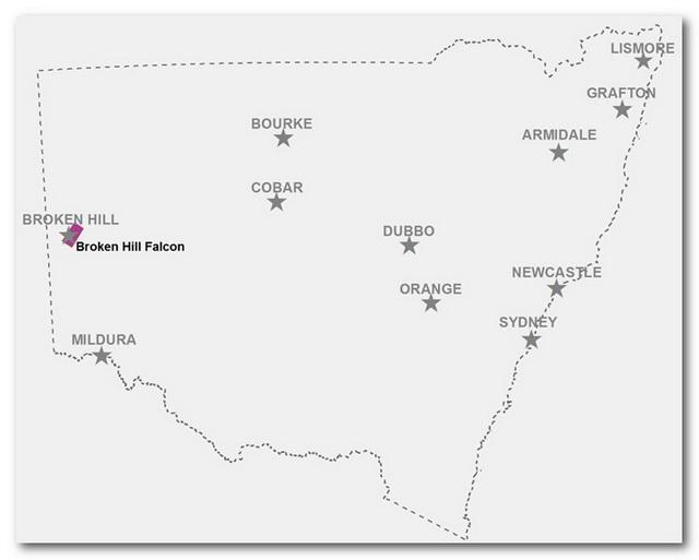
Location of government funded airborne gravity surveys
Airborne electromagnetic surveys
Airborne electromagnetic (AEM) surveys measure the conductivity of the ground down to a depth of a few hundred metres. Several government AEM surveys have been undertaken in NSW and can be downloaded for free from MinView.
Location of AEM surveys
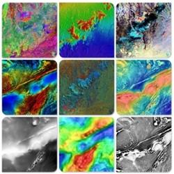
Hyperspectral data
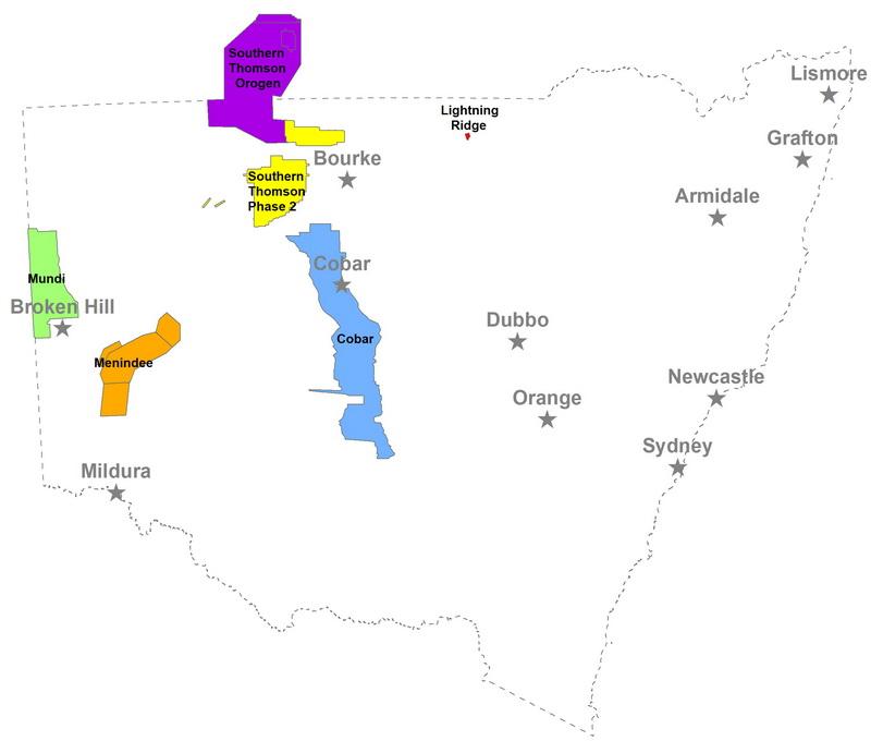
Hyperspectral surveys measure natural electromagnetic radiation from the ground at particular wavelengths. Hyperspectral data has been acquired around Broken Hill and can be downloaded for free through MinView.
Location of hyperspectral surveys
Statewide geophysics
Individual regional airborne and ground gravity survey grids have been merged together to produce statewide grids for the following data types:
- Airborne magnetics (25 m grid cell size)
- Airborne radioelements (100 m grid cell size)
- Airborne DEM (50 m grid cell size)
- Ground gravity (500 m grid cell size)
These filters and enhancements were applied to produce the following statewide grids:
- Total magnetic intensity (TMI)
- TMI reduced to the pole (TMI RTP)
- 1st vertical derivative (1VD TMI RTP)
- 2nd vertical derivative (2VD TMI RTP)
- Tilt anglefiltered (Tilt TMI RTP)
- Potassium %
- Thorium ppm
- Uranium ppm
- Digital elevation model (DEM)
- Spherical-Cap Bouguer gravity
- Isostatic gravity
Statewide images for TMI and TMI reduced to the pole can be clipped to areas of interest and downloaded from MinView using the tools-data download option. All other statewide grids can be requested by emailing geophysics.products@regional.nsw.gov.au.
Statewide geophysical images
Images were generated from the statewide grids and are presented in pseudocolour, greyscale or ternary colour schemes.
- TMI reduced to the pole (TMI RTP)
- First vertical derivative (1VD TMI RTP)
- Second vertical derivative (2VD TMI RTP)
- Tilt angle filter (Tilt TMI RTP)
- TMI reduced to the pole over tilt angle filter (TMI RTP on Tilt TMI RTP)
- Composite ternary image of potassium, thorium & uranium
- Digital elevation model (DEM)
- Bouguer gravity
- Isostatic Bouguer gravity
- Isostatic Bouguer gravity over TMI RTP tilt-filtered
The statewide geophysical images can be viewed in MinView. Images can also be clipped to areas of interest and downloaded using the tools-data download option in MinView.
1:250 000 geophysical imagery suites
Suites of geophysical imagery have been generated for each 1:250 000 map sheet area in NSW. They show the best resolution imagery available for the gravity and radiometric data, however the included magnetic data is from the 2014 statewide merge and no longer represents best resolution. Images are visualised with colour stretches optimised to enhance subtle features within the map-sheet area.
Each image suite can be downloaded from MinView and contains about 20 images which are projected in both GDA94 (latitude, longitude) and MGA zone. They are available in three georeferenced image formats (JPEG, ECW and TIFF). Geophysical imagery for each map sheet comprises:
- Aeromagnetic data : TMI, TMI RTP, 1VD TMI, 1VD TMI RTP, 2VD TMI, greyscale TMI, greyscale TMI RTP tilt-filter and TMI RTP over TMI RTP tilt-filter
- Gravity data : Bouguer gravity, isostatic Bouguer gravity, greyscale isostatic Bouguer gravity tilt-filter, isostatic Bouguer gravity over TMI RTP tilt-filter, and isostatic Bouguer gravity over isostatic Bouguer gravity tilt-filter
- Radiometric data : Ternary K/U/Th, potassium (%) band-pass filtered over SRTM DEM, thorium (ppm) band-pass filtered over SRTM DEM and uranium (ppm) band-pass filtered over SRTM DEM
- Additional : DEM, Landsat-7 principle components 1, 2 & 3
Open file company geophysical surveys
Exploration companies must submit geophysical data that they have acquired to the NSW Government to comply with exploration title reporting requirements. Surveys by exploration companies are usually higher resolution than government-funded regional surveys. Submitted geophysical surveys are indexed in the GSNSW database, which contains location and metadata for about 1200 company surveys throughout NSW. These surveys can be searched and discovered through MinView. The date for public release of survey data is listed in MinView and any data that are open-file can be downloaded directly.
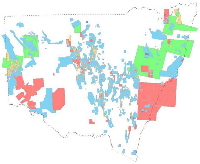
Airborne company geophysical surveys searchable in MinView
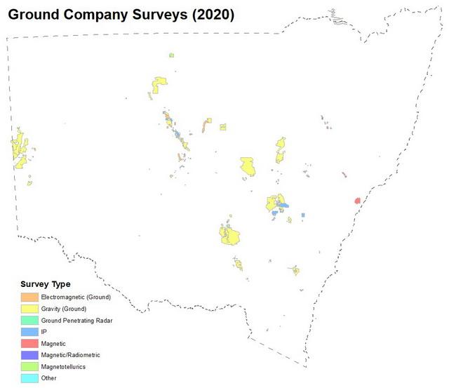
Distribution and types of company ground geophysical surveys searchable in MinView
Seismic surveys
Seismic surveys support the study of the stratigraphy and major structural and tectonic features of the basement rocks. All available seismic line data for NSW can be searched and downloaded through MinView.
Seismic surveys for onshore and offshore NSW
For further information
Contact Geophysics Products