Coastal Quaternary geological maps
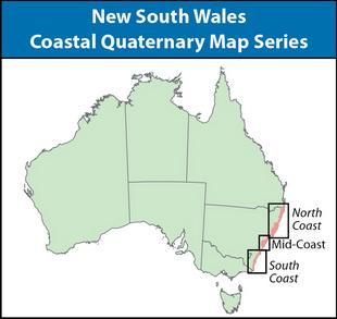
In 2005, the Geological Survey of NSW released high-resolution digital mapping data of the coastal Quaternary deposits of New South Wales as part of the Comprehensive Coastal Assessment.
Since then a series of 17 hard copy map products was produced from the digital data for the entire coast. The double-sided maps show a 1:100 000 overview of the area's Quaternary geology on one side and two to four maps of key areas at 1:25 000 on the reverse side (except for the Shellharbour-Kiama area map which is 1:50 000 and 1:25 000 respectively). Bulletin 34 Coastal Quaternary Geology – North and South Coast of New South Wales and a data package accompany the maps.
The map data represents a vast improvement on previous geological mapping in the coastal lowland areas of New South Wales due to the greater degree of differentiation of depositional units and a unique methodology that enabled the simultaneous mapping of surface and shallow sub-surface sedimentary deposits.
The Quaternary geology was combined with existing 1:250 000 bedrock mapping, and the GIS-based map product was linked to databases such as mining and quarrying activity, historical mineral sands mining, field sampling data and sediment characteristics.
Information contained in the mapping can assist with land-use planning and natural resource management issues, for example, through conversion to predictive maps of geological hazards, land-use capability, or location of extractive resources.
Mid-coastal products
- Central Coast Area Coastal Quaternary Geology Map
- Newcastle Area Coastal Quaternary Geology Map
- Wollongong Area Coastal Quaternary Geology Map
- Sydney Area Coastal Quaternary Geology Map
- Coastal Quaternary mapping of the southern Hunter to northern Illawarra regions, New South Wales (QN146)
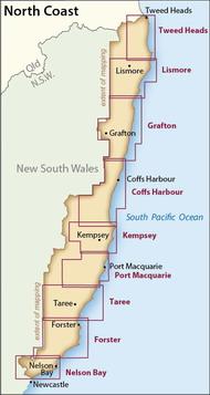
North Coast products
- Tweed Heads Coast Area Coastal Quaternary Geology Map
- Lismore Area Coastal Quaternary Geology Map
- Grafton Area Coastal Quaternary Geology Map
- Coffs Harbour Area Coastal Quaternary Geology Map
- Kempsey Coast Area Coastal Quaternary Geology Map
- Port Macquarie Area Coastal Quaternary Geology Map
- Forster Area Coastal Quaternary Geology Map
- Nelson Bay Area Coastal Quaternary Geology Map
- Taree Coast Area Coastal Quaternary Geology Map
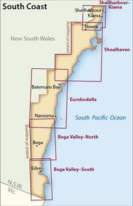
South Coast products
- Shellharbour-Kiama Area Coastal Quaternary Geology Map
- Shoalhaven Area Coastal Quaternary Geology Map
- Eurobodalla Area Coastal Quaternary Geology Map
- Bega Valley Coast Area Coastal Quaternary Geology Map
You might also be interested in
Ordering information