Regolith landform maps
Regolith mapping across NSW has been completed to understand the surficial mantle of weathered rock, sediments, soils, biotic complexes and water that are formed by the natural processes of weathering, erosion, transportation and deposition. Most regolith maps in NSW were completed as part of the Cooperative Research Centre - Landscape Environments and Mineral Exploration (CRC LEME).
Sixty one new regolith-landform maps ranging from 1:5 000 to 1:500 000 scale are available. All maps are print on demand. Where available, digital scans (JPEG format), rectified images (ECW format) and GIS vector data (ESRI Shapefile and MapInfo Table format) are provided as free downloads on the individual pages. Each map is viewable in Google Earth and Google Maps.
Regolith Maps 1:5 000 - 1:65 000
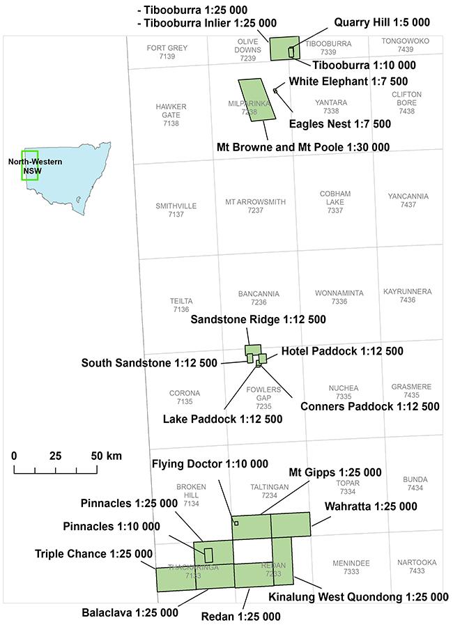
- Balaclava 1:25 000 Regolith-Landform Map
- Booberoi-Quandialla 1:50 000 Regolith-Landform Map
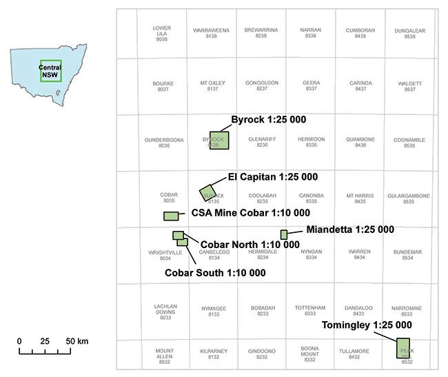
- Byrock 1:25 000 Regolith Landform Map
- Cobar CSA Mine Area 1:10 000 Regolith-Landform Map
- Cobar Gold Field North 1:10 000 Regolith-Landform Map
- Cobar Gold Field South 1:10 000 Regolith-Landform Map
- Conners Paddock 1:12 500 Regolith-Landform Map
- Cootamundra 1:65 000 Regolith Map
- Eagles Nest Catchment 1:7 500 Regolith-Landform Map
- El Capitan 1:25 000 Regolith-Landform Map
- Hazeldean Plug Area, Monaro Volcanic Province 1:10 000 Regolith-Landform Map
- Hotel Paddock 1:12 500 Regolith-Landform Map
- Kinalung West-Quondong West 1:25 000 Regolith-Landform Map
- Krawaree West 1:25 000 Regolith-Landform Map
- Lake Paddock 1:12 500 Regolith-Landform Map
- Miandetta 1:25 000 Regolith-Landform Map
- Mount Browne and Mount Poole Inliers 1:30 000 Regolith-Landform Map
- Mount Gipps 1:25 000 Regolith-Landform Map
- Nowra-Berry Special 1:35 000 Regolith-Landform Map
- Pinnacles (Pine Creek) 1:10 000 Regolith-Landform Map
- Pinnacles 1:25 000 Regolith-Landform Map
- Quarry Hill 1:5 000 Regolith-Landform Map
- Redan 1:25 000 Regolith-Landform Map
- Sandstone and Sandstone Ridge Paddocks 1:12 500 Regolith-Landform Map
- South Sandstone Paddock 1:12 500 Regolith-Landform Map
- The Flying Doctor Catchment 1:10 000 Regolith-Landform Map
- Tibooburra (Racecourse Creek) 1:10 000 Regolith-Landform Map
- Tibooburra 1:25 000 Regolith-Landform Map
- Tibooburra Inlier 1:25 000 Regolith-Landform Map
- Tomingley 1:25 000 Regolith-Landform Map
- Triple Chance 1:25 000 Regolith-Landform Map
- Wahratta 1:25 000 Regolith-Landform Map
- White Elephant Catchment 1:7 500 Regolith-Landform Map
- Wombat 1:25 000 Regolith-Landform Map
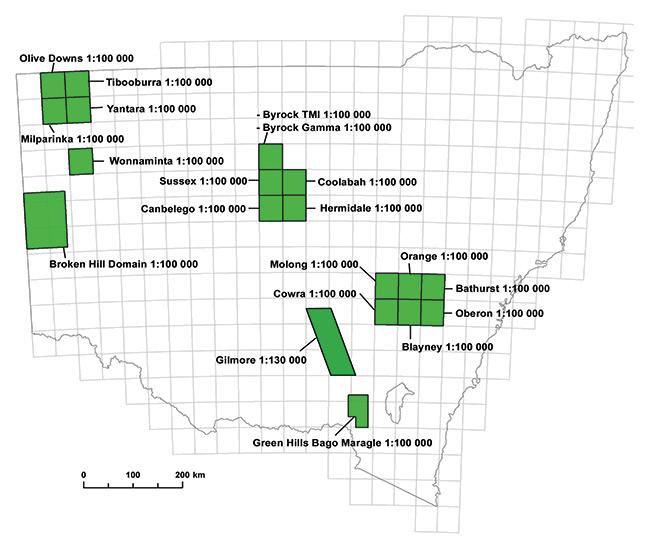
Regolith Maps 1:100 000 - 1:130 000
- Bathurst 1:100 000 Regolith-Landform Map
- Blayney 1:100 000 Regolith-Landform Map
- Broken Hill Domain 1:100 000 Regolith-Landform Map
- Byrock 1:100 000 Gamma-Ray Spectrometric With Regolith Overlay Map
- Byrock 1:100 000 Total Magnetic Intensity With Regolith Overlay Map
- Canbelego 1:100 000 Regolith-Landform Map
- Coolabah 1:100 000 Regolith Landform Map
- Cowra 1:100 000 Regolith-Landform Map
- Gilmore Project 1:130 000 Regolith-Landform Map
- Green Hills-Bago-Maragle State Forests 1:100 000 Regolith-Landform Map
- Hermidale 1:100 000 Regolith Landform Map
- Milparinka 1:100 000 Regolith-Landform Map
- Molong 1:100 000 Regolith-Landform Map
- Oberon 1:100 000 Regolith-Landform Map
- Olive Downs 1:100 000 Regolith Map
- Orange 1:100 000 Regolith-Landform Map
- Sussex 1:100 000 Regolith Landform Map
- Tibooburra 1:100 000 Regolith Map
- Wonnaminta 1:100 000 Regolith-Landform Map
- Yantara 1:100 000 Regolith-Landform Map
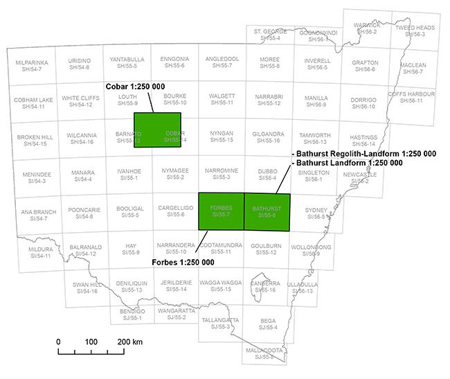
Regolith Maps 1:250 000
- Bathurst 1:250 000 Landform Map
- Bathurst 1:250 000 Regolith-Landform Map
- Cobar Special 1:250 000 Regolith-Landform Map
- Forbes 1:250 000 Regolith-Landform Map
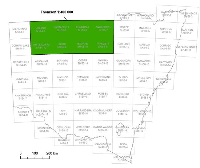
Regolith Maps 1:400 000
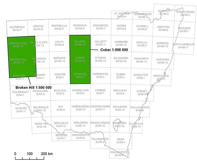
Regolith Maps 1:500 000
Index maps
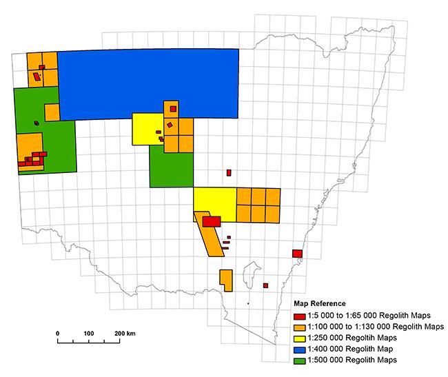
Regolith and landform index
1:5 000 - 1:65 000 North West NSW Index
1:100 000 - 1:130 000 index
1:250 000 index
1:400 000 index
1:500 000 index